A Short Introduction to the History of Bonby Village
Landscape and prehistory

Bonby sits within the Ancholme Valley which, along with the River Humber, were shaped into their present form by the grinding of glaciers during the ice age. These glaciers melted around 10,000 years ago and in the next 5,000 years (the Mesolithic period) people were active in the area and this is where we find the first evidence of people living in and around the Bonby area.
From flints to pottery we can trace evidence of human activity in the area throughout the Neolithic and Bronze Ages. Flint was used and with great skill tools were made and some of those lost while hunting, discarded or carefully placed in graves, such as this beautiful barbed and tanged arrowhead have been found in Bonby’s fields.
During this period important burials took place and were covered by circular mounds known as barrows, a number of which are evidenced on the Wold above Bonby close to the Middlegate.
Please Note
All of these finds have been responsibly reported to the H.E.R. They have been found on the surface of fields by fieldwalking. Two coins were also found on the surface and no metal detector has been used.
Roman and early mediæval

The Romans arrived a little under two thousand years ago, arriving in the Humber area around 48AD, and they left their marks locally particularly with an early villa at Worlaby and a later Villa at Horkstow from which a magnificent mosaic floor depicting a Chariot Race is available to be seen in Hull Museum.
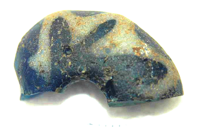
This blue and white bead was found within Bonby village. It is flat on the back and was probably used to adorn a sword, sheath or the likes. It dates to the Anglo-Saxon period and is made from reused Roman glass.
The Vikings were equally as elusive but have left us with a ‘by’ on the village name: in its earliest written form in the Doomsday Book it appears as Bunderbi. The ‘gate’ part of Middlegate is also Viking.
In the years following the Battle of Hastings in 1066 when the Normans took over the country a record was made for King William I that has become known as the Doomsday Book. From this record we can see the Village comprised little more than a handful of farmers in a former Viking farmstead.
Later and post-mediæval
Later and post-mediæval

Documentation available to us indicates that Bonby had once a “Priory” and a “Rectory” to date no evidence of either structure has come to life and whilst this doesn’t mean that they didn’t exist we need to be clear that these terms when used didn’t necessarily have the same meaning as that which we currently ascribe to them. For instance, a Priory might have only been a single monastic cell or a building run by a higher ranking Priory. Equally other more modern buildings might well have been built on the site of earlier more modest structures.
Our church (St Andrews) has parts identified as dating from the 12th Century. Records for the earliest building in the village come from Pope Alexander III who mentioned a church building in Bonby in documentation dated 8th March 1179. The “ownership & responsibility” of the Church has passed through many hands including the Benedictine Priory of St Fromund, in France. Merton Priory in England and a variety of landed families.
During the 14th Century a variety of dreadful events swept the countryside and Bonby was not excluded, these include
- the great famine of 1315- 1317.
- The start of the hundred years war with France in 1337
- The Black Death which arrived in Lincolnshire in 1349 and decimated the population.
- In 1362 the mother of all storms “the Grote Mandränke” came, wiping a number of East Coast villages completely from the map.
By 1374 Bonby’s land was mostly untilled and described as both a stony and sandy place was then hit when the Ancholme flooded making Bonby almost valueless. By this point in time the manor was reported to be in waste and with no buildings.
Until the 20th Century the area bordered by Sheepdyke, Main Street and Church Lane was little disturbed with the Vicarage tucked into the North corner and a Reading room tucked into the Southern side.
little disturbance to the soil and as such has been a treasure trove of archaeology as new developments have taken place.
The area for settlement in the village was naturally dictated by the availability of water and whilst Bonby is renowned for its seven springs (there are actually more) not all flow year round so the earliest dwellings will have been convenient for access to clean and available reliable water supplies. Whilst the water courses have changed and been moved over the years it is clear that the stream that runs beside the manor and down Carr Lane would have been a desirable source of water as it flows year round in plentiful state and naturally an area of settlement.
The name Sheepdyke came from the Sheep dipping in the Dyke at the corner of the road. A stream runs here and in years gone by was an opportunity for farmers to ensure that their animals were properly attended to.
Farmsteads and dwellings built up in this area with access to Middlegate along what we know now as Church Lane.
Pictured above is the vicarage with St Andrews Church to the side rear. This picture is believed to have been taken in 1912.
St Mary's Parish Church , Barton-upon-Humber
Burgate, Barton-upon-Humber, North Lincolnshire DN18 5EZ